
Massachusetts
The Photographs


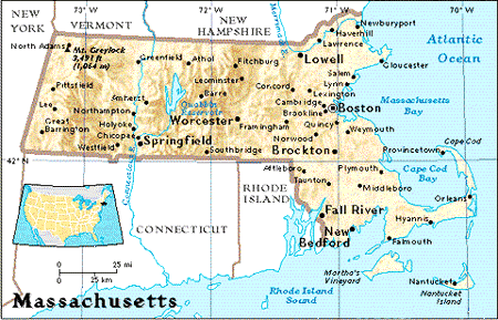
A Little Information About Massachutts
AREA: 21,456 sq km (8,284 sq mi).
POPULATION: 6,041,000.
CAPITAL: Boston.
ECONOMY: Industry: machinery, electric equipment, scientific instruments, printing and publishing, tourism. Agriculture: seafood, nursery stock, dairy products, cranberries, vegetables. PCI: $25,620.
ADMISSION: 6th of 13 original states.
TIME: GMT - 5. Daylight Saving Time is observed.
THE STATE: The gateway to New England (which comprises the States of Massachusetts, Maine, Vermont, New Hampshire, Connecticut and Rhode Island) was the destination of the Mayflower in 1620 and is one of the original 13 States. It is now very diverse, offering everything from cobblestoned streets and village greens to space-age technology centres. The Berkshire Hills cut across its western corner. To the east the land rolls down to the sea, embracing the State capital, Boston, and the beaches of the Cape Cod National Seashore. The two regions are divided by the Connecticut River Valley.
Earth Dream - Earth-Friendly Products, Gifts, and Resources - Earth-friendly books, organic coffee, music, animal-friendly personal and baby products, plush toys, puppets, aromatherapy, unique gifts, and more! Secure ordering is available. Also explore the Earth Dream Mall for other earth-friendly sites.
Canada
Connecticut
Home
Maine
Mid Atlantic
New Hampshire
New York
Rhode Island
Southeast
West

Please remember, all Photographs are for your viewing pleasure ONLY.
If you have any questions about copyrighted material, click here.
Copyright © 1998 Daniel J. Isbister
